
Trending
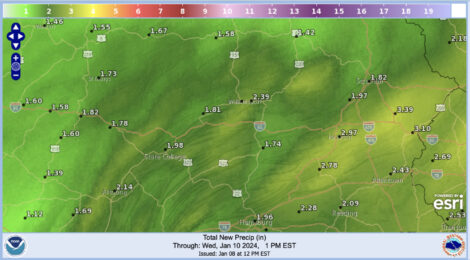
A potent low pressure system is expected to bring 1-3 inches of snow, a chance of freezing rain, and up to a whopping 3 inches of rain Tuesday and Wednesday -- all accompanied by howling winds with gusts upwards of 40 miles per hour. Worse: this storm is hitting a mere two days after the weekend snow storm which dropped several inches of snow across the region.
According to the National Weather Service, the juxtaposition of these storms is likely to bring mild to moderate flood risks throughout the region, as the pouring rains will melt the snow and add to runoff, especially early in the storm while drains and streams are clogged by snow and ice.
As of Monday afternoon, NWS hydrologic forecasts for area river stations include a Wednesday night crest of 12.9 feet at Lock Haven (action stage 17 feet); a Wednesday night crest of 9 feet at Renovo (action stage 12 feet); a Wednesday morning crest of 9.7 feet at Beech Creek (action stage 10 feet); and a Thursday morning crest of 14.4 feet at Jersey Shore (action stage 26 feet).
While most of the major stations in the Clinton County area are expected to stay under their action stages, it is worth noting that the Susquehanna River at Williamsport is expected to exceed its action stage by around 4 feet.
Smaller streams and creeks are more likely to rise quickly and flood, however, they are also expected to recede quickly, according to NWS.
The storm will lead off with a wintry mix of precipitation which may include a range of snow, sleet and freezing rain. The complexities of this system make it difficult to say how much of which type of precipitation is on the way, but as of this writing, NWS forecast discussions were saying that a winter weather advisory was likely to start the storm, in addition to the areal flood watch which was already in place as of Monday afternoon.
No significant accumulations of wintry weather are expected, in part due to the warming trend aloft which will convert the precipitation to rain for the remainder of the storm, likely around 2 p.m. or so.
Monday's overnight low of 27 will start things off chilly, but the high will rise to 46 during the day Tuesday, well outside of winter precipitation ranges, and the overnight low Tuesday is expected to be right around 40.
Unfortunately, the area's flood concerns will not be limited to the start of the week.
After this storm passes through, there will be a brief chance to dry out for a few days before another powerful low pressure system brings even more rain to the region Friday night through Saturday. Long range weather models are forecasting another 2+" of rain by midday Saturday, although as always, there is room for that to change as the day gets closer and the forecasts get more accurate.