
LHU geology students use new augmented reality sandbox
Trending
LOCK HAVEN-- The geology program at Lock Haven University has a powerful new educational tool to help students learn geologic and hydrologic concepts, such as landscape topography, how to read contour lines on a topographic map, and watershed processes.
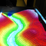
The hands-on augmented reality (AR) sandbox is combined with 3-D visualization applications that allow students to create topography models augmented in real time by a color elevation map with topographic contour lines.
Students move and shape the sand into hills and valleys and the landscape comes to life. Rainfall and flowing water can be simulated by waving a hand over the sand surface to momentarily act as a virtual rain cloud. Students can dig a deep hole to reach the water table and watch the hole fill with virtual water.
Dr. Ashley Burkett, assistant professor of geology, constructed the AR sandbox, and mounted the camera and projector hardware with the aid of geology major Adam Orcutt.
"I had seen an augmented reality sandbox demonstrated at a geology conference and decided to think big in terms of new approaches for student engagement and education at Lock Haven University," Burkett said. "I use the AR sandbox in principles of geology to demonstrate the rules of topographic maps in real-time and then encourage the students to experiment with it themselves."
The AR sandbox is also being utilized this semester in an honors course augmentation project related to mining, according to Burkett.
Dr. Loretta Dickson, associate professor of geology and chair of the Department of Geology and Physics, plans to use the augmented reality sandbox in her geology of national parks and structural geology courses.
"Map-reading skills are essential to successfully interpret the landscape and we laud Dr. Burkett's incentive and hard work to build this valuable tool that will help students develop spatial thinking abilities," Dickson said.
The augmented reality sandbox uses a 3-D Xbox camera to scan the sand surface in real time, and to detect hand gestures above the surface to create virtual rain clouds. The computer uses the scanned data from the camera to create an active topography map in real time. A projector mounted above the AR sandbox projects the topography map back onto the sand surface. Topographic contour lines superimposed on the sand terrain rapidly change orientation as the sand is shifted and moved and the map colors adjust based on changes in elevation.
Dr. Thomas Wynn, associate professor of geology, plans to use the augmented reality sandbox in Earth science, principles of geology, and geomorphology. "The AR sandbox will help students bridge the gap between the 2-D map and the 3-D world," Wynn said. "We can now model the effects of floods, landslides, and even meteorite impacts."
The augmented reality sandbox was constructed on a mobile cart that can be moved to different geology classrooms and laboratories. The teaching applications for the AR sandbox are abundant and wide ranging in many geology courses.
Dr. Md. Khalequzzaman, professor of geology, will use the AR sandbox in his hydrogeology, geographic information systems (GIS), and Earth resources and environment courses. "The AR sandbox will add a new dimension to several labs in each course and will help students visualize the 3-D surface of the Earth in a more direct way," Khalequzzaman said.
For more information on Lock Haven University, visit www.lockhaven.edu, email admissions@lockhaven.edu, or call 570-484-2011.