Fly-In History: Remembering the first Fly-In’s crash
-

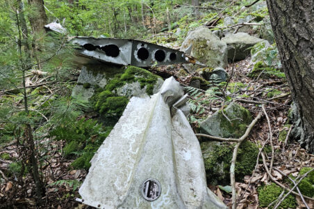
- PHOTO PROVIDED COURTESY OF BUDDY NASH The belly-up remains of a crash dating to the first year the Fly-In was held are pictured high up on the side of Bald Eagle Mountain.
-
- PHOTO PROVIDED COURTESY OF BUDDY NASH Wreckage from the plane is pictured strewn amidst boulders in the woods east of the felsenmeer on Bald Eagle Mountain.
-
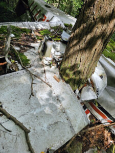
- PHOTO PROVIDED COURTESY OF BUDDY NASH Wreckage from the plane is pictured wrapped around a tree, which has since grown over top of the metal.
-
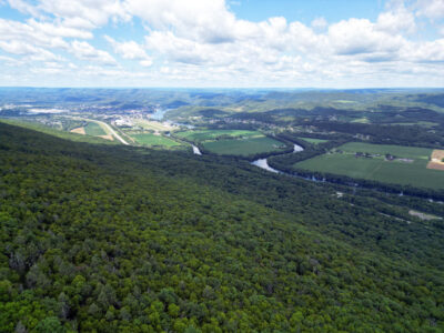
- PHOTO PROVIDED COURTESY OF BUDDY NASH A drone photo taken near the wreckage shows the the steep, dense forest through which Yatsko had to descend to reach Route 220. Lock Haven is seen sprawled at upper left.
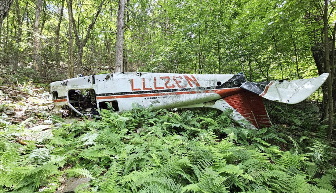
PHOTO PROVIDED COURTESY OF BUDDY NASH The belly-up remains of a crash dating to the first year the Fly-In was held are pictured high up on the side of Bald Eagle Mountain.
LOCK HAVEN — As aviation enthusiasts watch planes arrive and depart from the William T. Piper Memorial Airport during this week’s 38th annual Sentimental Journey to Cub Haven Fly-In, their gaze may be drawn to the rugged slopes of Bald Eagle Mountain. Here, the remains of a downed Piper aircraft stand as a poignant reminder of that inaugural Fly-In and the enduring legacy of flight in Lock Haven.
On July 16, 1986, pilot of 10-years John Yatsko, 32, of Hazelton, attended what would be Lock Haven’s first Fly-In, which now pays tribute to the city’s heritage as the former headquarters of Piper Aircraft, but was then just a small reunion for fans of the Piper Cub which had once been manufactured in the city.
The small, single-engine, two-seater airplanes, known for their simplicity of design and ease of operation, are a favorite of vintage aviation enthusiasts worldwide. More than 85 years since its introduction, the Cub remains one of the most influential and popular aircraft designs in Piper’s history.
According to news reports by the Hazleton Standard-Speaker and Wilkes-Barre Times Leader, Yatsko, a flight instructor and commercial pilot, flew to Lock Haven that morning in his 1975 Piper Cherokee. He intended to leave Lock Haven around 2 p.m., with plans to arrive back in Hazelton by 3 p.m. for a business meeting he had scheduled that afternoon. However, inclement weather that day arrived earlier than expected.
To avoid flying in hazardous conditions, Yasko filed a plan to fly back early using his plane’s instruments, and departed Piper Memorial Airport at 12:15 p.m.

PHOTO PROVIDED COURTESY OF BUDDY NASH Wreckage from the plane is pictured strewn amidst boulders in the woods east of the felsenmeer on Bald Eagle Mountain.
As he ascended through low elevation clouds, he noticed that one of his radios was not functional, distracting him.
Accounts vary about what happened next.
Contemporary reports attributed the crash to a wind shear (a difference in wind speed and or direction over a relatively short distance in the atmosphere) that caused his plane to flip over, but a 2023 interview by Hazelton’s Standard-Speaker with Yatsko instead indicated the accident happened when the Cherokee’s right wing clipped a tree on the mountainside.
Some time after crashing through the canopy on Bald Eagle Mountain, about 10 miles east of Lock Haven, he regained consciousness. Smelling gas and fearing the wreckage would ignite, he kicked out the door to the cockpit and stumbled out of the plane.
He would quickly realize the extent of his injuries as he negotiated his escape from the plane and began the trek to find help. Yatsko, who — among less serious injuries — had five broken vertebrae, two broken ribs and a swelled-shut right eye, spent hours traversing down the steep, slippery, rain-soaked mountainside, using trees and branches to support himself on his descent.

PHOTO PROVIDED COURTESY OF BUDDY NASH Wreckage from the plane is pictured wrapped around a tree, which has since grown over top of the metal.
It reportedly took hours before he reached U.S. Route 220, where he flagged down a car for help. The college-aged man and his girlfriend who found Yatsko reportedly believed he had suffered a chainsaw accident based on the amount of blood he had lost.
Upon arrival at Jersey Shore Hospital, he was inundated by medical professionals evaluating his injuries. Due to the extent of the injuries Yatsko needed to either be flown to Geisinger Medical Centre in Danville or driven to Williamsport Hospital. Given the choice, he opted to be treated in Williamsport, reportedly joking that he had “flown enough for one day.”
He would spend 29 days in the hospital and continue physical therapy for months. Yatsko would go on to make a full recovery.
Nearly four decades later, Piper Plane N32777 is still resting belly-up on the side of the mountain. Because of the remoteness of the crash and difficulty of the hike, the plane is largely intact.
The wreckage rests about 900 feet from the base of the mountain and there are no trails leading directly to the site. According to a blog post shared by Dan Wagner on Great American Hikes’ website, those interested in hiking to the crash will need a GPS and the exact coordinates (41.129646, -77.373703) to find the plane.

PHOTO PROVIDED COURTESY OF BUDDY NASH A drone photo taken near the wreckage shows the the steep, dense forest through which Yatsko had to descend to reach Route 220. Lock Haven is seen sprawled at upper left.
Wagner, who blogs about his hikes to plane crash sites, offered advice on getting to the wreckage.
The longer, safer route (8.5 miles) takes the Bald Eagle Mountain trails from Zindel Park. According to Wagmer, at the top of the Winchester Trail, enter the coordinates into your GPS, it should take you through a “very rocky and heavily wooded forest” for about a quarter of a mile. There, on the downward slope of the mountain, the crash can be found.
The second path takes you along a similar route to the one Yatsko took in 1986. Hikers can park along the berm of Route 220 near mile marker 114.6 and hike uphill to the site. The route is only 0.75 miles but is extremely steep.
Hiker and blogger Heather Truckenmiller wrote of the hike, “It is a scary steep descent, where you need a walking stick to know where it is safe to step, as many of the boulders will roll and move, and the moss has grown thick over deep holes between rocks that you do not want to step into and the leaves covering the ground are thick and slippery.”
Both hikes are only suitable for well-experienced hikers. For tips on hiking safety you can visit www.nps.gov/articles/hiking-safety.htm for more information.
For everyone else, spare a look at the mountainside this week — and remember that crash from so long ago.
Local news
Your family can be part of flag display for nation’s 250th year

Purr-fect plan: Fabulous felines garner attention for Centre County Library
Trump: US military has blockaded Iranian ports
CAIRO (AP) — U.S. President Donald Trump said Monday that the American military had begun a blockade of Iranian ...
Public review of Benner Pike to be conducted
STATE COLLEGE — The Centre County Metropolitan Planning Organization (CCMPO) invites the public to review and ...

Former Bellefonte council members call for councilman’s resignation