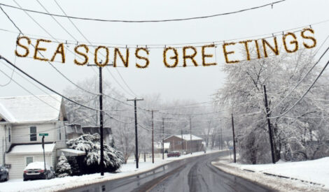
First snow of the season to arrive Tuesday morning

EXPRESS FILE PHOTO This image from 2019 shows that year's first measurable snow in Avis.
LOCK HAVEN — Just in time for the holiday season: measurable snow! Unfortunately for those of us who work or have school, the worst of this storm system is looking to arrive Tuesday morning.
Much of the region was already under a winter weather advisory as of Monday afternoon, with the National Weather Service noting that warning conditions may be possible — especially to our east.
The storm is expected to move very quickly, but be powerful while it is here. NWS forecasters have flagged potential snowfall rates of 1″ an hour as being possible with this storm. However, due to the storm’s speed, expected total accumulations are only around 3-5,” with some forecasters ticking that down to 2-4″ expected.
According to NWS, the bulk of the storm should only last for around six hours from start to finish, though some small pockets of showers may trail behind.
Despite the storm’s speed, high winds are not expected to be a factor with this system.
If you’re traveling that way, the worst of the snow is forecast to hit well to our northeast — Sullivan County up towards Scranton, for example.
PennDOT announced Monday that their crews were pre-treating major roadways throughout the area with salt brine.
“Roadways will not be free of snow while precipitation is falling. With freezing temperatures, roads that look wet may actually be icy, and extra caution is needed when approaching bridges and highway ramps where ice can form without warning,” a release from PennDOT cautioned.
While PennDOT recommends not traveling during winter storms, motorists can check conditions on more than 40,000 roadway miles, including color-coded winter conditions on 2,900 miles, by visiting www.511PA.com. 511PA, which is free and available 24 hours a day, provides traffic delay warnings, weather forecasts, traffic speed information and access to more than 1,200 traffic cameras.
511PA is also available through a smartphone application for iPhone and Android devices, by calling 5-1-1 or by following regional X alerts.
Motorists should always allow plenty of space when driving near plow trucks. Also, for their own safety and the safety of plow operators, motorists should never attempt to pass a truck while it is plowing or spreading winter materials.
Likewise, if you have to travel Tuesday morning, allow for plenty of time and exercise caution — remember that this is the first measurable snow of the year, which means that most drivers are not used to thinking about snowy conditions yet.
Additionally, the ability of this storm to produce intense snowfall rates will limit visibility, raising dangers on high-speed, heavily-traveled roads such as I-80.
After the storm passes through, look for the rest of the week to be a mix of clouds and sun, with temperatures generally hovering in the upper 30s, with the exception of Friday, which will be on the colder side.
The next storm system is forecast for Saturday, but should be a mix of rain and snow with slightly warmer temperatures keeping accumulations away. Further out, long-range models are showing an active pattern settling in for the region for the next few weeks, with at least the chance of a storm arriving every couple of days. However, much like this storm, all of them so far look to be fairly quick-moving, which should hopefully limit any substantial headaches.


